ISRO's Stunning Space View Of Cyclone Arnab: Where Is It Heading Next?
ISRO's INSAT-3DS satellite images show Cyclone Arnab moving northwards after landfall. Check its latest location, IMD forecast and rainfall alerts.

- Published
- Reading time
- 5 minutes
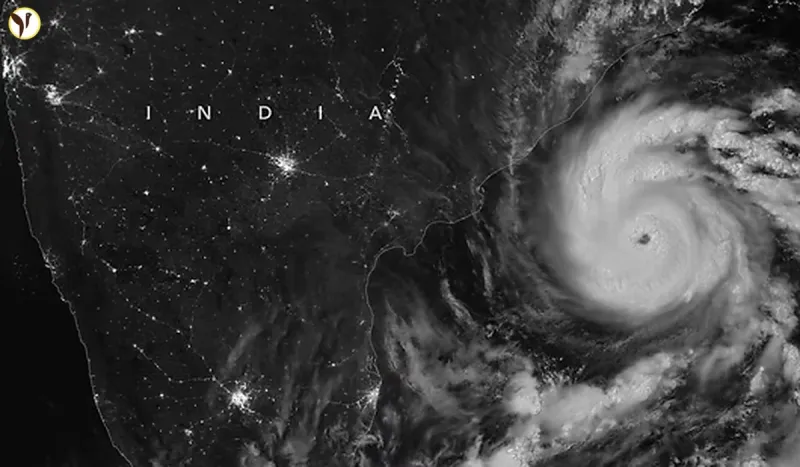
A stunning view of Cyclone Arnab from space has revealed how the powerful weather system moved across eastern and central India after making landfall along the Andhra Pradesh coast. Images captured by India's INSAT-3DS weather satellite show the movement of the cyclone's massive cloud system and how it gradually lost strength after reaching land.
The satellite images captured on October 29 and October 30 show a large area of dense clouds spreading across eastern and central parts of the country. However, the cloud formation became less organised as the system continued moving northwards.
Cyclone Arnab, which developed over the Bay of Bengal, had intensified into a Very Severe Cyclonic Storm before crossing the Andhra Pradesh and Yanam coast on October 28.
According to the India Meteorological Department (IMD), the system weakened significantly after landfall. Its remnants moved towards central India and continued losing strength.
The latest satellite observations have raised an important question: Where is Cyclone Arnab heading next, and which areas could experience rainfall because of its remaining weather system?
Here is everything you need to know.
What Do ISRO's Satellite Images Reveal About Cyclone Arnab?
India's INSAT-3DS weather satellite has provided important observations of Cyclone Arnab's movement.
The images captured on October 29 and October 30 show the cloud system moving northwards across eastern and central India.
The October 29 image showed a large and organised cloud mass covering parts of eastern and central India. By October 30, the cloud system had continued moving northwards, but its overall structure appeared less organised.
This change is important because it indicates that the cyclone was gradually losing its strength after moving over land.
The satellite observations also help meteorologists understand how the remaining cloud system is spreading across different regions.
INSAT-3DS is an Indian meteorological satellite designed to monitor weather systems, cloud patterns, atmospheric conditions and cyclones.
Its observations help the IMD track developing weather systems and issue warnings when required.
Where Is Cyclone Arnab Right Now?
Cyclone Arnab has already crossed the Andhra Pradesh coast and weakened considerably.
According to the IMD's October 29 update, the remnant depression moved northwards and weakened into a well-marked low-pressure area over central Chhattisgarh and adjoining Odisha.
This means Arnab is no longer an active powerful cyclonic storm.
Its remaining circulation and associated cloud system have continued moving inland.
The weather system is now being monitored mainly for its possible rainfall impact rather than the threat of powerful cyclone-force winds.
The IMD's latest assessment is therefore different from the earlier forecasts issued when Arnab was still over the Bay of Bengal.
How Did Cyclone Arnab Move Towards India's East Coast?
Cyclone Arnab developed over the Bay of Bengal on October 26, 2026.
Initially, it was a deep depression before intensifying into a cyclonic storm.
The system then strengthened further and became a Very Severe Cyclonic Storm.
Its movement towards the Indian coastline prompted weather warnings for several coastal areas.
Where Is Cyclone Arnab Heading Next?
According to the IMD's October 30 weather bulletin, the remnants of Cyclone Arnab were located over north Chhattisgarh and adjoining East Madhya Pradesh at 8:30 AM.
The system is expected to weaken further as it moves towards the northeastern parts of Chhattisgarh and neighbouring areas.
This means the focus has shifted from cyclone-force winds to the possibility of rain and thunderstorms.
The IMD is also monitoring the movement of the remaining circulation to understand its impact on nearby regions.
For now, Arnab is not expected to regain its earlier cyclone strength.
Which States Could Experience Rain Due To Cyclone Arnab?
Although Cyclone Arnab has weakened, its remaining cloud system and moisture can still influence weather conditions.
The satellite images show extensive cloud cover over several eastern and northeastern regions.
These include:
- Odisha
- Chhattisgarh
- Jharkhand
- West Bengal
- Parts of eastern and northeastern India
However, cloud cover does not automatically mean heavy rainfall in every location.
The actual rainfall intensity will depend on local weather conditions and the movement of the remaining circulation.
Residents should follow the latest IMD district-level forecasts instead of relying only on satellite images.
Is Another Cyclone Developing Over The Andaman Sea?
Another important development has appeared in the latest weather observations.
The IMD has identified a separate low-pressure area over the South Andaman Sea and adjoining Andaman and Nicobar Islands.
According to its October 30 bulletin, this system is likely to move west-northwestwards and intensify into a depression over the southeast Bay of Bengal and adjoining areas around October 31.
After that, it is likely to move towards the Andhra Pradesh coast during the following two days.
However, this is a separate weather system and should not be confused with Cyclone Arnab.
The development is being monitored because it could influence weather conditions over the Bay of Bengal and nearby coastal areas.
Why Are Satellite Images Important For Tracking Cyclones?
Satellite images play an important role in modern weather forecasting.
They allow scientists and meteorologists to observe weather systems over oceans and remote areas where ground-based observations are limited.
India's INSAT-3DS satellite provides important information about:
- Cloud movement and formation.
- Development of thunderstorms.
- Cyclone location and movement.
- Atmospheric moisture.
- Changes in weather patterns.
These observations help the IMD understand how a cyclone is developing, whether it is becoming stronger or weaker, and which regions may experience its impact.
Satellite monitoring also helps weather agencies prepare warnings and communicate possible risks to the public.
Conclusion
Cyclone Arnab's journey from the Bay of Bengal to eastern and central India has been captured through satellite observations.
The latest images show that the system has weakened considerably after making landfall over Andhra Pradesh on October 28.
As of October 30, its remnants were over north Chhattisgarh and adjoining East Madhya Pradesh, with further weakening expected.
Meanwhile, a separate low-pressure system over the South Andaman Sea is attracting the attention of weather experts.
The coming days will be important for monitoring rainfall patterns and the development of this new weather system.
For the latest updates, people should follow official announcements from the India Meteorological Department.
Questions readers ask
What do ISRO's satellite images show about Cyclone Arnab?
The INSAT-3DS satellite images show Cyclone Arnab's cloud system moving northwards across eastern and central India while gradually losing strength.
Where is Cyclone Arnab currently located?
According to the IMD's October 30 bulletin, its remnants were over north Chhattisgarh and adjoining East Madhya Pradesh.
Has Cyclone Arnab made landfall?
Yes. Cyclone Arnab crossed the Andhra Pradesh and Yanam coast on October 28, 2026.
Has Cyclone Arnab weakened?
Yes. It weakened from a Very Severe Cyclonic Storm into a depression and subsequently a low-pressure area.
Which satellite captured Cyclone Arnab?
India's INSAT-3DS meteorological satellite captured images showing the movement of its cloud system.