Hurricane Isaias: 121-Year Record, Landfall, Georgia Impact
Isaias became the latest first Atlantic hurricane of a season in 121 years, then came ashore near Destin as a Category 2. Outages, rainfall totals and the Georgia flood threat.

- Published
- Reading time
- 6 minutes
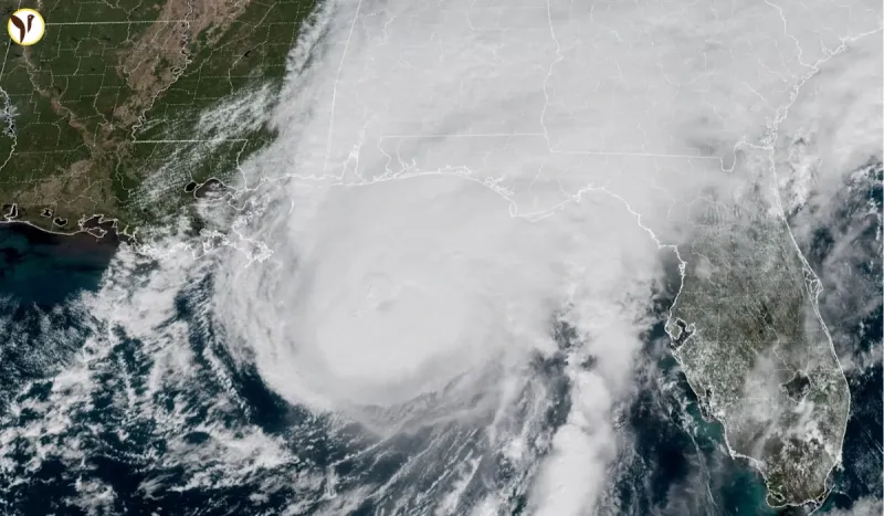
Isaias became a hurricane on 7 October the latest first hurricane of an Atlantic season in 121 years. Two days later it came ashore near Destin, Florida as a Category 2 storm, and by early Saturday it had cut power to more than 760,000 customers across the Southeast while the National Hurricane Center downgraded it to post-tropical.
Both halves of that sentence are unusual, and they are connected.
A season that reached October with nothing
The Atlantic hurricane season runs from June to November. In a typical year the first hurricane has formed by mid-August. This year the basin produced tropical storms and nothing stronger, week after week, through the entire climatological peak and then produced its first hurricane on the seventh of October.
According to NOAA data, that is the latest first hurricane in an Atlantic season in 121 years. The only later start on record came on 8 October 1905. Isaias missed that mark by a single day.
A quiet season is not the same as a safe one, and this is the clearest illustration of why. One storm arriving late can still come ashore at major hurricane strength, and the fact that nothing had happened by the end of September told coastal residents nothing useful about what the first week of October would bring.
What it did on the way in
Isaias formed as a tropical storm in the Gulf and strengthened quickly. By Friday morning it was flirting with Category 3 strength, and it peaked at around 120 mph sustained winds a major hurricane before beginning to weaken on its final approach.
Landfall came on Friday evening near Destin, on the western Florida Panhandle. Accounts of the exact timing differ slightly, placing it between about 8pm and 9:30pm ET. It arrived as a Category 2, with maximum sustained winds reported at 105 mph and a minimum central pressure of 971 mb.
The wind readings on the ground tell the story better than the category does. The strongest gust logged was 118 mph near Jay, Florida. Santa Rosa Sound recorded a 116 mph gust with sustained winds of 91 mph. Storm surge at Panama City Beach reached 5.6 feet above normal tide, against a forecast of 6 to 9 feet above ground level between the Alabama–Florida border and Grayton Beach.
Rain was the bigger number. DeFuniak Springs, Florida recorded 12.46 inches the highest total reported and Bellwood, Alabama also topped a foot.
DESTRUCTION REVEALED ‼️: Numerous camper vans are flipped over after Hurricane Isaias whipped through Navarre Beach, Florida, bringing damaging wind gusts, torrential rainfall and life-threatening flooding. Isaias made landfall Friday as a Category 2 hurricane near Destin, Florida. #florida #isais #hurricane #destin
— FOX Weather (@foxweather) October 10, 2026
The downgrade that makes things worse, not better
At 2am ET on Saturday the National Hurricane Center declared Isaias post-tropical. The remnants moved over Alabama and Georgia.
This is the part of a storm's life cycle where people relax, and where a certain kind of harm starts. "Post-tropical" is a statement about a system's structure it has lost its tropical characteristics, its warm core, its organised circulation. It is not a statement about how much water is falling out of it.
Parts of southern Georgia are under a rare Level 4 of 4 flash flood threat, the highest level forecasters issue. A Level 3 of 4 risk covers northern Georgia and the Blue Ridge, including the Atlanta metro area. A tornado watch covered parts of southern Georgia into Saturday morning, part of a wider watch over more than 850,000 people.
The National Hurricane Center's rainfall forecast was 4 to 8 inches with up to 15 inches in coastal areas, and 2 to 5 inches across much of the rest of the Southeast with isolated totals to 10 inches. Those are flash-flood numbers in catchments that are already saturated.
So the storm is weaker and the danger in Georgia is higher. Those two things are both true at once, and the headline downgrade is the reason some people will get caught.
Where the power is out
Outage figures move constantly, so these carry their timestamps.
More than 760,000 customers were without power across the Southeast at 1:51am ET, concentrated in the Florida Panhandle. At the last per-state readings, Alabama was above 250,000, Florida at 375,000 and Georgia above 10,000 and climbing. An earlier count from PowerOutage.us had put the three-state total above 697,000.
Georgia Power said it was monitoring the system and had pre-staged line and tree crews for widespread outages the standard pattern before a storm whose damage comes from trees falling onto distribution lines rather than from the wind itself. In south Georgia, thousands were already out on Friday evening. Several major weekend events across the state were altered or moved.
Governor Brian Kemp declared a state of emergency in Georgia ahead of the impacts. In Alabama, Governor Kay Ivey ordered non-residents, tourists and visitors in parts of coastal Baldwin and Mobile counties to evacuate immediately. Florida Governor Ron DeSantis described Isaias as a major hurricane and stressed that storm surge, not wind, causes the most serious damage. Dauphin Island Mayor Jeff Collier said his main worry was whether people would heed the warnings at all. The White House said it was tracking the storm closely.
No deaths have been reported in any account available at the time of writing.
If you are in the path, the hazard has changed shape
The wind threat is largely finished. What is left kills differently, and the precautions are specific.
Flood water is the main risk now. Most flood deaths in the United States happen in vehicles. Six inches of moving water can take a car's traction and a foot can float most of them, and you cannot judge depth or whether the road beneath is still there. If you reach water across a road, turn around including on a route you drive every day. Barricades are there because someone has already checked.
Treat every downed line as live. Power lines on the ground, in standing water, or caught in a fallen tree should be assumed energised. Stay well clear, keep others clear, and report them to the utility rather than approaching.
Generators belong outdoors only. Carbon monoxide from a generator run in a garage, a porch, a basement or a crawl space kills people every storm season, including with the door open. Outside, well away from windows and vents, is the only safe placement. The same applies to charcoal grills and camp stoves, which should never be used indoors for heat or cooking during an outage.
Assume the outage lasts longer than the storm. Tree-driven damage to distribution networks takes days to repair, not hours. Charge what you need now, keep the fridge and freezer shut, and check on neighbours who rely on powered medical equipment.
Local emergency management agencies and your own utility's outage map are the authoritative sources on restoration and road closures, and they will be more current than any news report.
What to watch
The remnants were forecast to track across Alabama and into the Tennessee Valley through the weekend. The flooding risk follows the rain, not the storm's name, so the hazard moves inland with it.
And the record stands. An Atlantic season reached October without a hurricane for the first time since 1905, and then produced one that came ashore at Category 2 and left three quarters of a million customers in the dark. Whatever else the season does, that is the part worth remembering.
Questions readers ask
Where and when did Hurricane Isaias make landfall?
Near Destin, on the western Florida Panhandle, on the evening of Friday 9 October 2026. Accounts place the exact timing between about 8pm and 9:30pm ET. It arrived as a Category 2 hurricane with maximum sustained winds reported at 105 mph and a minimum central pressure of 971 mb, having peaked earlier that day at around 120 mph — major hurricane strength.
Is Isaias still a hurricane, and what does post-tropical mean?
No. The National Hurricane Center declared Isaias post-tropical in its 2am ET Saturday advisory. Post-tropical describes a system that has lost its tropical structure — its warm core and organised circulation. It says nothing about how much rain the system is still producing, which is why the flooding threat in Georgia rose even as the classification fell.
Why was Isaias a record-setting storm?
It became a hurricane on 7 October, making it the latest first hurricane of an Atlantic season in 121 years. The only later start on record was 8 October 1905, according to NOAA data, so Isaias missed that mark by a single day. The Atlantic produced tropical storms through the whole climatological peak of the season without any of them reaching hurricane strength.
How many customers are without power?
More than 760,000 across the Southeast at 1:51am ET on Saturday, concentrated in the Florida Panhandle. At the last per-state readings, Alabama was above 250,000, Florida at 375,000 and Georgia above 10,000 and rising. These figures change constantly — your utility's outage map is the current source.
What is the flood risk in Georgia, and what should people do?
Parts of southern Georgia are under a rare Level 4 of 4 flash flood threat, the highest level issued, with a Level 3 of 4 risk across northern Georgia and metro Atlanta. Governor Brian Kemp declared a state of emergency. Most US flood deaths happen in vehicles: six inches of moving water can take a car's traction, so turn around rather than driving through water across a road, even a familiar one. Treat every downed power line as live, and run generators outdoors only, well away from windows and vents.